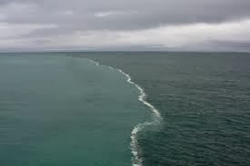
GOLF OF ALASKA
The Gulf of Alaska is an arm of the Pacific Ocean defined by the curve of the southern coast of Alaska, stretching from the Alaska Peninsula and Kodiak Island in the west to the Alexander Archipelago in the east, where Glacier Bay and the Inside Passage are found.
The entire shoreline of the Gulf is a rugged combination of forest, mountain, and a number of tidewater glaciers. Alaska's largest glaciers, the Malaspina Glacier and Bering Glacier spill out onto the coastal plain along the Gulf of Alaska. The coast is also heavily indented, with Cook Inlet and Prince William Sound the two largest connected bodies of water, but also including Yakutat Bay and Cross Sound. Lituya Bay is the site of the largest recorded tsunami in history and is a popular sheltered anchorage for fishing boats.
Ecology
The Gulf of Alaska is considered a Class I, highly
productive ecosystem (more than 300 grams of carbon per square meter per year).
Many deep water corals can be found in the Gulf of
Alaska. Primnoa pacifica has
contributed to the location being labeled as Habitat Areas of Particular
Concern. P. pacifica is typically a deep water coral normally found between
150 metres (490 ft) and 900 metres (3,000 ft) here.
Meteorology
The Gulf is a great generator of storms.
In addition to dumping vast quantities of snow and ice on southern Alaska,
resulting in some of the largest concentrations south of the Arctic Circle, many of the storms move south along the coasts
of British Columbia, Washington, Oregon,
and as far south as Southern California
(primarily during El Nino events). Much of the seasonal rainfall and snowfall in
the Pacific Northwest and Southwestern United States
comes from the Gulf of Alaska.
